Showing posts with label Hell's Canyon. Show all posts

Friday, June 1, 2018

Hell's Canyon adventure

Ticks.
Heat.
Terrain.
Lightning.
Poison ivy.
Rattlesnakes.

These are some of the words to describe a place from which we just returned.

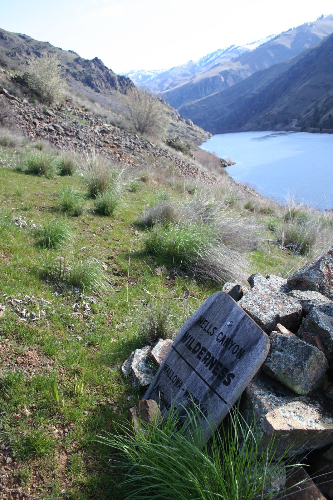
It was a four day backpack trip into the Hell’s Canyon National Recreation Area, and it maybe should have been a six day trip.

We left the house on a Friday, and took three hours to reach the trailhead at Freezeout.  The parking area was packed with about 10 pick-ups with horse trailers, and 5 or 6 cars/suv’s.  We were hiking by 10:30 and the first 5 kilometers were uphill, past open pine forests and vast open grassy hillsides.


Freezeout Saddle was the site for lunch, and then the 15 kilometers of downhill along Saddle Creek started.  There are a few places where the trail is difficult to find; this is when you need to use your route finding skills.  The trail crosses the creek to the south side for about a half a kilometer, and the vegetation gets very dense.  A hiker wades through two meter tall poison ivy, along with other plants such as thimbleberry, alder, serviceberry.

The first camp of the trip was at the mouth of Saddle Creek along the mighty Snake River.  That night was an long duration lightning storm, with considerable rainfall.  We didn’t know it at the time, only after we returned, that the Joseph-Imnaha Highway that we used to access this area, had been washed out and was impassible.  We weathered the weather, and in the morning everything seemed clean and new.


The shortest hiking day was day  two, where we strolled north for 8 kilometers, along the Snake to Rush Creek, and found a smooth, grassy area next to the rushing creek.  The afternoon was spent lounging, napping, and casual birding, as well as watching jet boats and rafts negotiate the rapids.

Then the arduous part of the trip commenced.  The map and guide book indicated that the trail was on the south side of Sluice Creek.  We hefted our packs onto our back and started up the trail.  It immediately became clear that the trail wasn’t.  There were brambles of blackberry growing 2 and 3 meters tall on the trail.


We veered further south, hiking along the steep north aspect until it became too steep and we dropped down to the floodplain.  Then we hiked along the gravelly shore of the creek, until that became impassible.  We crossed the creek to the north side and stayed along the riparian area.  After three hours we had made about 1.5 kilometes, and looking back could see a new, improved trail higher up on the north side.  Had we taken it we would have saved 2.5 hours of frustrating bushwhacking.  Now we know.

The next five kilometers of the Sluice Creek Trail were rather pleasant.  The trail slowly climbed through a twenty year old burn that had some snags, some live ponderosa pine, but was mostly open grassland with a heavy shrub component.


It was along this segment that I puzzled about some biology.  In the fall and winter different species of birds will congregate in mixed flocks.  You might have seen a flock of birds with a woodpecker, chickadees, juncos, creepers, and kinglets, all hanging out in the same general area.  While we were marching up the Sluice Creek Trail I thought I was observing a mixed nesting flock.  Spotted towhees were squawking, at the same time there appeared a Nashville warbler, with food in it’s beak, and a calliope hummingbird was pearched, watching the entire show of us walking by.  Could it be that different species of birds nest close together as a defense mechanism?  More eyes and ears could help to alert a nesting bird of predators or other hazards.  It’s an untested theory.  Or maybe it has been tested and I just haven’t heard of the research.

The end of the Sluice Creek Trail is at the junction of the High Trail.  This should have been where we camped for there was a very nice campsite amoungst the large pines, but like a knucklehead, I pushed on, thinking that the more distance we do this day would lessen the distance on our last day.  What a knucklehead.


The High Trail winds among the drainages along a bench between 4000 and 4500 feet elevation.  It’s fairly mellow, but after the arduousness of Sluice Creek, it still wasn’t very welcoming.  And there were very few places to camp.  Another five kilometers brought us to a relatively flat area near Log Creek.  Other members of the party had been dead tired for several kilometers, so any campsite would have been a welcoming sight.


The final day was a casual stroll for five kilometers back to the Saddle Creek Trail, then 3 kilometers over Freezeout Saddle, 5 kilometers downhill, and back to the car.  A seemingly tame dusky grouse posed for images in full display, although he refused to allow us an unobstructed view of him.


Weather during the extended weekend was very good for hiking.  The first three days were overcast, with temperatures between 15 and 20.  Friday night got hot and humid until the downpour and lightning, when it cooled off and made for good sleeping.

The most numerous bird could be a toss-up between lazuli buntings, yellow-breasted chats, and yellow warblers.  It seemed those three species were everywhere.


Humans did not seem as plentiful as the parking lot indicated.  We saw 2 backpackers and a horseman the first day,  about ten students and advisor from Western Connecticut University the second day, two backpackers from Boise the third, and two backpackers from Portland the final day.  A few mule deer were seen, and two mountain goats spotted with binoculars below Hat Point.  Fence lizards, two rattlesnakes and one gopher snake were also seen during the stroll.


Monday, March 21, 2016

Hell's Canyon National "Recreation" Area


On a recent trip into the Hell's Canyon National Recreation Area I had a few thoughts. Not many, but a few.

Hell's Canyon in on the border of Oregon and Idaho, and the Snake River both divides the States, and provides a center for the NRA. On both sides of the river are steep, rocky, grassy canyon walls creating the deepest canyon in North America. Yes, deeper than the Grand Canyon.

On this three day trip I contemplated the management of the NRA. What is being done in the Area, and what should be done?

A National Recreation Area could be just about anything a person wants it to be. The fable of the seven wise, blind people who were told to go find an elephant and report back to the King. Each wise person touched a part of the elephant and reported back such things as an elephant is a rope (from the person who only touched the tail) to the one who reported the elephant is a page made of leather (from the person who touched the ear of the elephant).

So, this is only one blind person touching Hell's Canyon NRA. And one of the first things I touched was a sign-in box:

There are no forms, no paper, nothing, in the box. They don't want to know what your recreational needs are. And last year there were no forms. The five or six times I've checked this box there has been nothing in it. It's only to make a person think that the Forest Service is interested in your recreational needs. Nothing more.

Not too many more meters along the trail a person walks through a thicket of blackberry brambles:

Introduced from Eurasia, Himalayan blackberry (Rubus armeniacus) is a non-native invasive. It doesn't belong in the area. And it is spreading, requiring trail users to hack back the canes annually to keep the trail clear.

Further along the trail a recreation user gets the official greeting of entering the Hell's Canyon Wilderness Area:


The sign is propped up against the rock pile. The Forest Service apparently can't even mount the sign properly on a pole. It's just sitting next to the trail as if the USFS personnel didn't have the time or energy to spend a little extra time to install the sign on an official post.

There are native plants in the area, and you can see them in the above image with the sign. Those clumps of grass are the native bluebunch wheatgrass (Pseudoroegneria spicata). But many of the natives are being overrun, or outcompeted with the non-natives. Call them what you will: non-native, exotic, weedy, invasive, foreign, they don't belong in the area and take over from the naturally occurring native plants.

Here's a pretty image of the Spring Creek drainage with a foreground full of non-native thistles:


Non-native bull thistle (Cirsium vulgare) occupies a large area of this bench and might be considered the dominant species in the area. It is a biennial, meaning that it usually takes two years to flower, then it dies. So all the tall, skeletons of bull thistle are dead.

But looking closer to the ground a person sees:
Bull thistle! This plant was busy establishing itself last year, and this year it will be ready to take off,  send up a nearly two meter stalk which will flower, and send out hundreds of seeds.

Non-native thistles are not the only forbs that are dominating the area. There's teasel:

Like thistle, teasel (Dipsacus fullonum) is biennial and these are the remains of last year's seed heads.

Looking around a person can easily find the plants that will be making this year's flowers and seed heads:

Teasel was one of the plants in North America that was intentionally introduced. It was brought to this continent so settlers could use the seed head for carding wool. Now it seems to just be a problem.

The above images have been focused on specific plants and problems, but what happens if a person just takes a picture of the plants at his feet?

Where to start? The deep green plant on the left edge is teasel. The gray-green plant near the top of the image is known as beggar's lice, gypsyflower, or houndstongue (Cynoglossum officinale), another biennial non-native. It produces tick sized and shaped seeds that stick to people's clothing.

On the right side of the image is the skeletal remains of last years medusahead wildrye (Taeniatherum caput-medusae), a non-native annual grass.

The green grasses in the above image could be some of many non-native grasses that have their remains in the area. Besides the medusahead, there was cheatgrass (Bromus tectorum), bulbous bluegrass (Poa bulbosa), Kentucky bluegrass (Poa pratensis), and wiregrass, also known as North Africa grass (Ventenata dubia). Many of these species are considered winter annuals, meaning that the seeds germinate in the autumn, winter over as small plants, then when spring and warmer weather begins, they have a head start on growing. This allows the winter annuals to suck up the limited soil moisture and nutrients faster than the plants that don't germinate until the spring.

All of these non-natives in our National Recreation Area!

What could possibly be the source of so many alien species of plants?

Is there a finger a person could point to a likely vector of these weeds?
Let the first person who is free of sin cast the first cowpie!

Domestic cattle are allowed to graze much of the Hell's Canyon National Recreation Area, sometimes for up to six months. While there were no cattle in the area in March, 2016, their remains were everywhere. Maybe this allotment has cattle on it in the early summer, after the grasses have had an opportunity to grow a bit taller.

Do US Forest Service personnel ever get out in the field anymore? Or are budgets so tight that there are no personnel to do field work? Or has the mission of the Forest Service sifted so far that they have abandoned being land stewards and have all become suppressors of wildfires?

It perplexes some. The geography of Hell's Canyon has not changed. It is still, and will continue to be a big gorge. It will continue to be a place of big spaces. What is changing is the seeming neglect that the managers of this special place have. Neglect. And it is visible everywhere a person looks.

One final image that sums it all up:
This is along the Thirtytwo Point Trail (#1789), at the junction with the Buck Creek Trail (# 1788). It's the only indication that there is a trail junction here. If a person wasn't paying attention they might miss the junction. But, interestingly, the sign has not been replaced in the twenty to thirty years that the wildfire had occurred in the area.


Twenty years, and they haven't replaced the sign. It is only a sign, but it is a sign also of the mismanagement of your National Recreation Area.

Friday, June 20, 2014

Why I love wild lands


I thought I wrote a poem about why I love wilderness, but this is what the USDA Forest Service posted on one of their websites:
The beauty of the canyon, the vastness of bluebunch wheatgrass waving in the wind, the wild ungulate on the hillside, are just some of the wonders that cause me to love wilderness. The snake in the grass, the innumerable rocks just waiting to twist my ankle
the poison ivy along the river trail, the exposed ridges during a summer lightning storm. The jewel that is every flower, the blue sky waiting for the change in weather, the ancestors who walked here before are more of the wonders that I love about our wildernesses.

Hell's Canyon near Deep Creek
And this is what I wrote with the proper formatting:
Why I love Hell's Canyon Wilderness:

The beauty of the canyon,
The vastness of bluebunch wheatgrass waving in the wind,
The wild ungulate on the hillside,
Are just some of the wonders that cause me to love wilderness.

The snake in the grass,
The innumerable rocks just waiting to twist my ankle
The poison ivy along the river trail,
The exposed ridges during a summer lightning storm.

The jewel that is every flower,
The blue sky waiting for the change in weather,
The ancestors who walked here before
Are more of the wonders that I love about our wildernesses.

I suppose it's no big deal. Although I do prefer the way I wrote it over the way the FS published it. Maybe it is just a little quibble.