Tuesday, July 13, 2021

Backpacking the Kalmiopsis

Have you ever gone somewhere nearby that almost seems otherworldly?  Have you ever traipsed out into your backyard only to find something foreign and unknown?

In 1987 I was in southwest Oregon for work, helping save the world as a wildfire suppressor.  I thought it would be nice to return and see the place in a different light, in other words, in the non-smokey light of a bright sun.  Thirty-four years later I did get back and we backpacked into the Kalmiopsis Wilderness Area.

Shouldn't have waited sooo long.
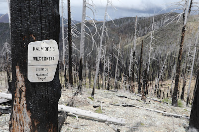
The edge of the Wilderness.

The parking lot was deserted, empty, and nobody was around when we left the Babyfoot Lake trailhead and headed south.  The trail had been maintained a year or two earlier, so it was no surprise to have to climb over a couple downed snags.  There were flowers everywhere, mostly on the shrubs, but also many of the forbs were in full flower.

The two nights we spent were near the site of Bailey Cabin.  There had been a long history, some very recent, of mining in the area.  Many of the trails had been roads to mines.  


Leftovers from the mining heydays.


And then there were the wildfires.  The wildfire I was a part of trying to suppress was a little ways north of where we backpacked.  This area had been burnt in the 2002 Silver Fire.  There may have been another some years later, but the fact is that most of the conifer overstory was in the form of dead snags.  Some people may be saddened to see so many dead trees.  We were rejoicing at the response of the plant life resulting from the pulse of nutrients from the burned biomass.  The shrubs and other plants were resplendent this time of year.

Kalmiopsis leachiana

How many wilderness areas are named for a plant?  Usually the name reflects a local geologic feature--a mountain or river such as Mount Jefferson Wilderness, or North Fork Umatilla Wilderness.  Occasionally an area is named for a famous person, hence The Bob Marshall Wilderness.  But what about plant names for wilderness areas?  In Oregon there is one, and one only,  Wilderness Area named for a plant, Kalmiopsis.  The plant, a small shrub in the heath family that is found in southwest Oregon, was in full flower when we visited. 

Other plants were also splendidly displayed.  Rhododendron, azalea, ceanothus, current, and even poison oak.  Not all of the overstory had been burnt in the wildfires, but it was mostly sparse.


Walking through a Jeffrey pine forest.

Was this what the area looked like before Euro-Americans started suppressing wildfires?  Some of the conifers in the area, such as knobcone pine, require fire for their cones to open and release their seeds.

On the second day we day hiked down to the mighty Chetco River.  We would have gone on, pushing north along the river, but soon encountered a wall of poison oak.  Fifty percent of our party is very susceptible to developing dermatitis from the oils of poison oak, so we turned around.   After a leisurely lunch along the turquoise blue Chetco we wandered back to base camp, peak bagging Bailey Mountian on the return.


The mighty Chetco River.


Nighttime camp near Bailey Cabin site.


Looking north across much of the Kalmiopsis Wilderness Area.

We hiked out the ten kilometers on the third day.  We were within two kilometers of the trailhead when we saw the only other people of the trip--Gabe and his friend were starting a 5 day loop.

Hiking past the Ribes.


California lady slipper.

It was a great three days.  But the standard disclaimer applies:  Don't go there.  Stay away.  This place is not for you.

Don't go there because you can see the flowers right here.  I leave you with some of the outstanding flora of the Kalmiopsis Wilderness Area.

This is the flower of the California pitcher plant (Darlingtonia californica).

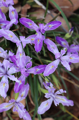
Douglas' iris (Iris douglassii)

Large flowered rhododendron (Rhododendron macrophyllum)


Thursday, April 29, 2021

Nature in the Honeycombs Wilderness Study Area

What sort of flora and fauna can one see along the Oregon Desert Trail?  On a recent walk on the ODT through the Wilderness Study Area known as The Honeycombs we observed a few animals and plants.  It may have been a little too early for some of the creatures, but in the desert the plants usually don't flower for very long, and the animals are usually hiding because it's too cold, or too hot.  So our observations were strictly limited to the three days we were hiking the Trail.


Allium lemmonii.  Lemmon's onion.

Phlox longifolia.  Long leaved phlox.


Phlox hoodii.  Hood's phlox.

Taeniatherum caput-medusae.  Medusahead wildrye. 
Not native anywhere in North America.

Trifolium macrocephelum.  Big-head clover.  
The only native clover that has more than three
leaflets, usually five to eight.

Fritillaria pudica. Yellow Bells.
In the lily family it is also known as yellow fritillary.

Balsamorhiza hookeri.  Hooker's balsamroot. 
One of two species of balsamroot we saw.

Castilleja species.  Paintbrush.
Lots of species with variations of flower color.

Purshia tridentata.  Bitterbrush.
The scent of bitterbrush perfumed the air reminiscent
of sweetness and licorice.

Amilanchier utahensis.  Utah serviceberry. 
The smell of this flower is disappointing compared to
the smell of the Saskatoon serviceberry (A. alniflolia).  

Paeonia brownii.  Brown's peony.

Balsamorhiza sagittata.  Arrowleaf balsamroot.

The remains of a pronghorn.

Not quite a full curl from a bighorn sheep.

Side-blotched lizard.
One of the most common lizards in eastern Oregon.

Black widow arachnid.
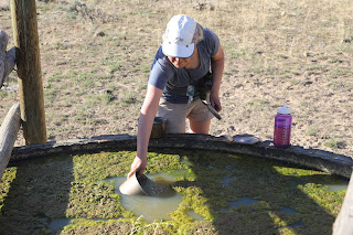
Found in a springbox.  Just don't 
look in there.

Gopher snake.  Note the remains of medusahead
wildrye.  The small forb in the lower right is Alyssum
alyssoides, a common non-native spring annual.

Rumour had it that there were feral (or wild) horses in the area.  We never saw any, but they left their calling cards in big piles throughout the area.  A few mule deer were seen, as well as some lagomorphs such as cottontails rabbits.

All in all, a fine trip.  But not recommended if you are going to do that stretch anytime we might be doing it.  Stay away!  Thanks.


Honeycombs and the Oregon Desert Trail


The Honeycombs Wilderness Study Area is located on the east side of Lake Owyhee in Eastern Oregon.  It is a rugged area chock full of stunning red and yellow walls of rock.  Our destination was to hike the segment of Oregon Desert Trail (ODT) through the Honeycombs, from Leslie Gulch to Lake Owyhee State Park.

So, here we go.

We left the trailhead in Leslie Gulch and headed up Juniper Gulch at lunchtime.  It was also Saturday, and the parking lot was full, with 18 vehicles, mostly big pick-up trucks.  This was not starting very well.  Ten people, twenty people passed us heading down and back to their vehicles.


The lower part of Juniper Gulch.


Lunch was taken in the shade of a large reddish-yellow obelisk.  A few more day-hikers were walking downhill.  There was no water in any of Juniper Gulch, but the view was spectacular.


The view from the head"waters" of Juniper Gulch
.

We left the people the minute we left Juniper Gulch.  It would be three days before we saw another person.  The ODT is a route along most of it's distance and we were starting to experience hiking a route.  There had been a trail along much of the Gulch, but beyond was grassland and shrubland, and occasional animal trails.


Ridge walking.

Strolling down canyon, into what some have labeled "Let'r Rip Canyon" we saw the remains of pronghorns and bighorn sheep.  And lots of leavings from the feral horses.

The curl of a bighorn sheep.

Into an unnamed canyon.

Known by others as Let'r Rip Canyon.  (Not on any maps).

Our first campsite was near a "spring".  It may have been suitable for bovines, but left us with a sense of drinking some extra protein.  We tried filtering the water, but ended up with a cup of milky water and a clogged filter.  So we boiled.

The spring was somewhat dry.

Upstream from camp was a good water source.

We slept well the first night, although we had hiked a measly twelve kilometers.

Nighttime near OC171.

From Craig Canyon we hiked up, over, then down into Painted Canyon.  We dropped our backpacks and took a stroll down canyon, and down memory lane.  Somewhere down there, on a rocky outcrop of volcanic tuff, I proposed to C, forty years ago.  We never relocated the actual place, but we did find a nice pool of refreshing water to fill our bottles.

Painted Canyon.

Fresh, clear, cool, water.

Walking past classic honeycombs formation.

Hard to get lost when you can only go a certain direction; up canyon or down canyon.  But sometimes the sagebrush was tall enough to hide even a tall backpacker.

The big valley.  Soon to be a major motion picture.

The walls of Painted Canyon.

Negotiating a pour-off.

A short break had me wondering about the distribution of the flavours of Skittles.  I'd already consumed the orange and purple, but they were both under two from this fun-sized bag.


What's the most common Skittle?  Let me graph that.

Twenty-one kilometers of hiking and we were too lazy to put up the tent.  Actually, we wanted to do a little star watching, as the moon was close to new, and the sky would be dark.

Cowboy camping on night two.

We continued our northward journey on day three.  The craggy canyons of the first two days were replaced with vast rolling grasslands.  The federal agency managing the public lands had actively altered the landscape years ago by eliminating much of the shrub component.  They did this with the intention of increasing forage for domestic livestock.  It made for easy hiking.

Sunshine.

Three Fingers from a distance.

Montana does not have exclusive use of the phrase big sky.

There were a couple places with water, a spring and two reservoirs which may dry up in the summer.  But as we're walking along, from a distance, we see what look like two blue plastic barrels.  Litter, we assume.  As we get closer we recognize it as two groups of water jugs, full.  Were they just placed there?  All ten jugs were sealed and unopened.  We left them for the summertime hikers who would need them more than us.


Another excellent spring.


Free water, you pack.

Past Calhoun Reservoir (very dry) and down into Birch Creek, eighteen kilometers later we were finished with this segment of the Oregon Desert Trail.  

Strolling to the finish at Lake Owyhee State Park.

Most guides of the ODT indicate it starts in the Badlands Wilderness to the east of Bend, Oregon and finishes 700 miles later at Lake Owyhee State Park.  That would be a Central Oregon centric way of looking at the trail.  Another perspective would be the start of the trail begins at Lake Owyhee and ends in the Badlands.  The Eastern Oregon perspective.  Either way, in either direction, the trail is a truly astounding experience for those seeking solitude and vast landscapes.